Privacy & cookies
Donaubergland GmbH
Development of a web app all about the Danube Sinkhole
October 2023 to April 2024

In the period from October 2023 to April 2024, a pioneering project to enhance tourism in the municipalities of Immendingen, Möhringen, Fridingen and the town of Tuttlingen was implemented in collaboration with Donaubergland GmbH. The aim was to develop a web app for the topic of Danube seepage in order to give visitors a holistic understanding of the fascinating phenomenon of Danube seepage. In this natural phenomenon, a significant proportion of the Danube water between Immendingen and Fridingen disappears underground, while the other part continues to flow above ground. This means that the Danube flows into two seas - the Black Sea and the North Sea at the same time.
The main objective was to create a user-friendly digital platform that allows interested parties to present information about the Danube infiltration in an easily accessible way. In close cooperation with Donaubergland GmbH, various existing open data sets were brought together and combined in a clearly organised guide. The newly programmed interface to the GNTB Knowledge Graph was used for the first time in this project. This brings together data from various sources, such as the Baden-Württemberg state tourism database "mein.Toubiz". The aim of the interface is to minimise the maintenance effort on the part of the customer. In future, data such as addresses, description texts or events are to be maintained centrally and displayed in several sources - such as the MAQNIFY© Guide for the Danube seepage.
The MAQNIFY© Guide to the Danube infiltration offers a wide range of functions to provide visitors with comprehensive information. In addition to presenting places of interest, the web app also includes information on places to stop for refreshments and overnight accommodation as well as leisure and cultural facilities in the region. The integration of car parks and public transport also makes travelling easier. A total of over 100 POIs (points of interest) are included. Web app users can also discover selected hiking routes and cycle tours, filter them thanks to clickable categories and tags and plan their own personalised journey in the Donaubergland region. An overview map with the POIs provides orientation, while pictures give a vivid impression of the local area.
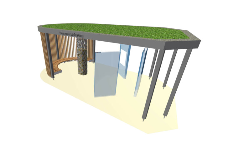
As an additional service, three info points on the Danube infiltration phenomenon will be set up in the municipalities of Immendingen, Möhringen and Fridingen from summer 2024. These info points offer the opportunity to access the Danube seepage web platform directly via QR codes without having to download a separate app.

Info-Point 3D model © Donaubergland Tourismus GmbH